

Nature Reserves & Conservation Areas
Big Scrub and Beyond
"protecting habitats from the mountains to the sea"
Photos © by D & J Palmer, Big Volcano Tourism, unless otherwise cited.
When visiting our national parks and nature reserves, please minimise your environmental impact by following these guidelines. If you use a tour operator or guide service, ask them if they observe the Ecotourism Operators Code of Practice.
Please also note that only local nature reserves with visitor facilities like walking tracks, interpretive signage, picnic tables and toilets, or permitted visitor activities, are listed here.
Webmaster: Advisories on this page checked/updated: 4pm, 1st June, 2022.
Some Northern Rivers region local closures include full park closures (Wollumbin NP), or part closures due to flood or bushfire damage, or for upgrades to camp grounds, facilities, walking tracks etc. Please check all alerts list for the full list of NSW national parks closures before planning your visit.
Please also check any park alerts current for Gold Coast and Scenic Rim parks.
Valuable Refuge Areas
"Nature reserves are considered to be valuable refuge areas where natural processes, phenomena and wildlife are protected and can be studied. Nature reserves differ from national parks as they do not include provision of recreation opportunities as a major objective of their management.
The purpose of a nature reserve is defined under the NP&W Act as being:
- the care, propagation, preservation and conservation of wildlife;
- the care, preservation and conservation of natural environments and natural phenomena;
- the study of wildlife, natural environments and natural phenomena; and
- the promotion of the appreciation and enjoyment of wildlife, natural environments and natural phenomena."
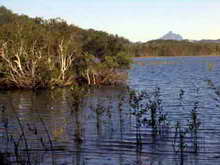
Billinudgel Nature Reserve
 Originally dedicated in 1996 with additional lands to the north and south dedicated in 1997, this reserve has an area of 713 hectares, and forms one of several coastal nature reserves which protect important remnants of coastal habitat in an otherwise highly modified environment.
Located east of the Pacifc Highway between South Golden Beach in Byron Shire and Wooyung in Tweed Shire, this reserve protects a large tract of natural lowland coastal vegetation, along with an extensive wetland containing Melaleuca swamp forest, and a diversity of habitats which supports a wide range of fauna and flora including rare, threatened, significant and migratory species.
Day use facilities are limited to walking tracks only, with interpretive signage at trail entry points. It's a great place to go bird watching and to explore a subtropical coastal environment which is now rare.
Billinudgel Nature Reserve, Birds of Billinudgel sign, courtesy of Byron Bird Buddies
Broken Head Nature Reserve
There are few places in New South Wales where the rainforest truly meets the sea. Broken Head is one such place, protecting one of the most outstanding scenic and natural areas of coastline in NSW.
Walking tracks offer sweeping vistas and provide access to secluded beaches with their backdrop of windsheared rainforest. Tracks leave from along side the Broken Head Caravan Park and at other localities along Seven Mile Beach Road, and camping is permitted only in the council managed caravan park.
Day use facilities include a carpark (parking restrictions now apply), toilets, picnic tables, free barbecue facilities, drinking water, and cold showers.
Please note that due to its proximity to Byron Bay, it is very popular and crowds are common at all times of year.
To get there, follow the signs for the caravan park along the Coast Road just south of Suffolk Park and Byron Bay.
Brunswick Heads Nature Reserve
Brunswick Heads offers the magical combination of beach, estuary and littoral rainforest. There is little to beat it on a hot summer day or if you are looking to escape the hectic pace of life in a busy coastal town.
Located just off the Pacific Highway on the northern side of the Brunswick river, it is the ideal location for a picnic, swimming, or simply cooling your heels and dangling a line.
Cape Byron State Conservation Area (SCA)
Cape Byron Lighthouse and museum closure.
Cape Byron Headland Reserve stands on the most easterly point of the Australian mainland, with a spectacular cliff top walking track offering panoramic views of the ocean and north coast hinterland.
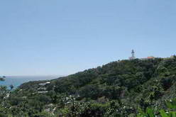
The reserve is an outstanding spot for observing a range of marine life including turtles, dolphins and humpback whales on their annual migration.
A 3.7 kilometre walking track winds through diverse coastal plant communities, including rainforest that stretches all the way to the beach. The boardwalk from Captain Cook Lookout to Brooke Drive is pram and wheelchair accessible. However, most parts of the track are steep, with many steps. Ref.
You can join the walk loop track at a number of points, including from the various car parks. The walk is rated moderate to hard, and will take around two hours, as you stop at various lookouts along the way to recover your breathe, enjoy the views and to take photos to remember it all.
More than 100 years old, the Byron Bay lighthouse has an interesting display of historical artifacts and items, and the visitor centre in the original lighthouse station, offers an insight into the history of the lighthouse and reserve, with each room given over to various themes. Guided tours which include a climb of the lighthouse tower, are available by arrangement, and holiday accommodation is available in a number of heritage cottages located within the reserve.
Entry Fees
Entry is free to pedestrians, but as parking is limited and the road up to the lighthouse is almost always busy, vehicle parking fees* apply at the lighthouse ($8 for cars, $4 for motorbikes, coaches from $22-$72).
If you have a NSW National Parks Pass, it maybe free. Additional parking is available at Byron Shire Council car parks outside of the lighthouse precinct, where it's $4 per hour, including the Cosy Corner and The Pass car parks at the foot of the cape.
*As at 21 June, 2017. See also Byron Bay Pay Parking for details.
Cook Island Aquatic Reserve
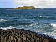
One of the few NSW islands, Cook Island Aquatic Reserve is located approximately 600m offshore from Fingal Head and four kilometres southeast of Tweed Heads.
The reserve includes the waters within and around Cook Island to a 500m radius from a survey marker on the island (approximately 78 hectares).
Cook Island offshore © courtesy of Dede Callichy.
Originally called Turtle Island in 1823 by John Oxley when his party took shelter in the lea of the 10-acre islet during a storm, in 1828 Captain Rous conducted the first survey of the Tweed River and gave the island its present name, after Lieutenant James Cook, who had logged the island in his voyage journal in 1770, but didn't name it.
The Aquatic Reserve was declared on October 23 1998, to protect the marine biodiversity of the island's reef system, and hosts a great diversity of marine life resulting from the warm east Australian current from the north converging with cooler currents from the south.
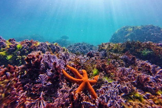
Temperate, subtropical and tropical species of fish, crustaceans and molluscs are found around the island, and it is also visited or inhabited by a number of protected species including the Giant Queensland Groper, black cod, estuary cod and the grey nurse shark.
Cook Island, Julian Rocks in the Cape Byron Marine Park, and the Solitary Islands in the Solitary Islands Marine Park east of Coffs Harbour, provide 'stepping stones' for tropical larvae dispersal down the coast. All these islands are now marine protected areas.
Cook Island Aquatic Reserve offers a range of activities including swimming, whale watching, boating, snorkelling and scuba diving. Fishing by all methods is prohibited for all waters from the mean high water mark on the island to a boundary defined by five marker buoys.
Cook Island underwater scene © courtesy of Bryan Ricketts Photography.
Cudgen Nature Reserve
 Located on the Tweed Coast Road, just west of Cabarita (Bogangar), this reserve comprises Cudgen Lake, Round Mountain and
areas north and south of Clothiers Creek Road.
Located on the Tweed Coast Road, just west of Cabarita (Bogangar), this reserve comprises Cudgen Lake, Round Mountain and
areas north and south of Clothiers Creek Road.
Open seven days a week from 8am to 4pm via Clothiers Creek Rd access adjacent to Cabarita Lake Apartments, this delightful reserve comprises 54 hectares of mixed coastal vegetation, with a dramatic mix of important remnant vegetation types found here, including littoral and subtropical rainforest, dry and wet sclerophyll forests, swamp forest, heathlands, woodlands, grasslands and mangroves.
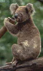
A number of rare and endangered plant species are known to occur here, and the reserve area has been previously identified as one of the remaining significant Koala habitats on the Tweed Coast. An Aborginal stone quarry on the edge of the lake provides evidence of local habitation.
At 464 hectares including the whole of Cudgen Lake, the reserve offers picnicking, bushwalking and nature study in a truly unique range of habitats.
Iluka Nature Reserve

Bordering the southern boundary of Bundjalung National Park, and on the northern fringe of the coastal village of Iluka, this 136ha World Heritage area preserves the largest stand of Littoral Rainforest in New South Wales.
Picnic facilities are provided at Ilkua Bluff where an informative display ensures that your visit will be an educational one, and the viewing platform provides spectacular coastal views over the ocean.
This unique area is ideal for a day visit, with a 2.5 kilometre walk meandering through the rainforest from the Iluka Bluff parking area to Iluka village.
With more than 140 bird species recorded in the area, and well known for Noisy Pittas who forage in the leaf litter beside the walking track, bird watchers can enjoy spotting a wide range of species along the way.
If you're staying in the seaside town of Yamba on the southern side of the Clarence river, it's an ideal day trip across on the Clarence River Passenger Ferry (just make sure you get back to the jetty in time to catch the last departure back to Yamba!)
![]()
Moore Park Nature Reserve
Just off the Summerland Way near Old Grevillia, 26 kilometres north west of Kyogle and south of Woodenbong, this tiny nature reserve is the most important example of Black Bean Rainforest in New South Wales and is all that remains of an area once known as Boyd's Scrub.
It is considered the largest and best remaining example of lowland subtropical rainforest in the state, with more than 127 native plant species recorded. It's also a well known Grey-headed flying fox camp*, with the animals dominating the reserve for up to eight months during the year.
A great place for a swim and family picnic, there is a shelter shed, picnic tables and toilets provided for your convenience.
* NSW NPWS asks that visitors be careful not to disturb the camp when it's occupied.
Tucki Tucki Nature Reserve
In 1958 local residents worried about disappearing koala habitat initiated tree plantings which now form the core of Tucki Tucki. Extensive additional plantings over the years have now more than doubled the area available.
A small colony of this much loved Australian marsupial now lives in the reserve, and while we can't guarantee that you will see one during your visit, looking is half the fun.
A short graded walking track and picnic facilities are provided within the reserve, which is located along the road from Lismore to Woodburn.
Take the time while your are there to visit the Aboriginal Bora Ring a kilometre back down the road towards Wyrallah. It is fenced and marked with a description board.
Tyagarah Nature Reserve
A daily vehicle entry fee applies to this nature reserve at the end of Grays Lane, which protects a coastal dune system between Byron Bay and Brunswick Heads.
Eight kilometres of unspoilt beach and an impressive backdrop of coastal heath await visitors. There are bushwalking tracks behind the dunes that bushwalkers and birdwatchers can enjoy exploring, or you can go for a quiet walk along the beach, looking out for whales during the migration season.
Access is ten kilometres north of Byron Bay off the Pacific Highway. Limited parking is available opposite public toilet facilities, and it's a short walk to picnic tables located in dunes behind the beach.
Clothing optional beach
Please note that the beach area adjacent to the reserve, south of the picnic area at the end of Grays Lane, has been designated a "clothes optional beach" by Byron Shire Council. The clothes optional area stretches for 800m and starts 200m south of Grays Lane.
While most people tend to access the "clothes optional" section closer to Byron Bay, from North Belongil Beach via Bayshore Drive, visitors to Tyagarah Nature Reserve via Grays Lane entry, should be aware of this known use. NSW NPWS states; "Please note that the beach south adjacent to the reserve is designated as a ‘Clothes Optional Area’." (https://www.nationalparks.nsw.gov.au/things-to-do/picnic-areas/tyagarah-nature-reserve-picnic-area, accessed 25/11/20)
See also: 28th Jan 2018: Tweed Daily News; Police fine 15 people for nudity, sex on beach.
Victoria Park Nature Reserve
Located approximately seven kilometres south of Alstonville on Wardell Road, Victoria Park is well placed for a day visit from Lismore or Ballina.
It is hard to imagine that this tiny remnant of rainforest is nearly all that is left of an area once known as the "Big Scrub", believed to have once covered an area of some 73,000 hectares.
By 1900 this largest area of tall subtropical rainforest was all but totally destroyed by the timbergetters of the time. While only 17.5Ha in area, Victoria Park contains 8Ha of undisturbed rainforest.
Birdlife is plentiful here, where 152 different tree species have also been identified, with many examples of strangler figs, along with white booyong, yellow-wood, bumpy ash, red bean and Moreton Bay figs.
Wild growing examples of the Macadamia Nut tree (Macadamia tetraphylla), Australia's first native food plant to be commercially grown, can be found in the park.
An informative display and track signs cater for the enquiring mind. A specially constructed boardwalk is suitable for wheelchairs, and other walking tracks allow you to travel back in time beneath a canopy of towering trees.
Facilities include car parking, shelter shed, fireplaces, picnic tables and toilets.
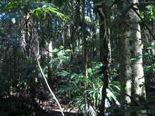
Whian Whian State Conservation Area
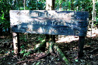
A former state forest, Whian Whian State Conservation Area (SCA) was created in 2003 to protect an area surrounded by Nightcap National Park.
You can camp or picnic in the rainforest at Rummery Park - a former logging camp, where there's easy access and you can enjoy some of the day walks, or go on a mountain bike ride.
Rummery Park campground facilities include picnic tables, showers, toilets and shelters.
It is very popular during school holidays, and with overnight bushwalkers trekking the Historic Nightcap track from Mount Nardi, about 18km to the west.
The campground is maintained by NSW NPWS, while the SCA assets (forest, flora and fauna) are under State Forest control for their "potential exploration".
Wilson Nature Reserve
One of the eleven major remnants of the "Big Scrub", Wilson Nature Reserve covers an area of 27 hectares. A 1km walking track starts from either Wyrallah Road or the reservoir on City View Drive out of Lismore.
This reserve contains the only significant patch of Dry Rainforest left from the "Big Scrub", and is significant for the presence of Sweet myrtle (Austromyrtus fragrantissima), the endangered Marbled frogmouth, and a small Koala population.
Wooyung Nature Reserve
Wooyung Nature Reserve is is located on the far north coast of NSW between Pottsville to the north and the locality of Wooyung to the south, and consists of 87 hectares of coastal land bisected by the Tweed Coast Road.
Mooball Creek constitutes the reserve's western boundary, while the eastern boundary is the mean low water mark of the South Pacific Ocean along approximately 2.5km of Mooball Beach and Wooyung Beach.
The reserve was gazetted as a nature reserve on 1st January 1999, and named as Wooyung Nature Reserve due to its proximity to the township of Wooyung, as well as the part inclusion of Wooyung Beach within the boundaries of the reserve.
More information >> Wooyung Nature Reserve
Webmaster: Advisories on this page checked/updated: 4pm, 1st June, 2022.
Some Northern Rivers region local closures include full park closures (Wollumbin NP), or part closures due to flood or bushfire damage, or for upgrades to camp grounds, facilities, walking tracks etc. Please check all alerts list for the full list of NSW national parks closures before planning your visit.
Please also check any park alerts current for Gold Coast and Scenic Rim parks.
References and Readings
- Billinudgel Nature Reserve: Instagram embed retreived 17/01/22 used with permission of https://www.instagram.com/m_m2483/
- Cook Island offshore photo © courtesy of Dede Callichy.
- Cook Island underwater scene ©, used with permission of Bryan Ricketts Photography. https://www.facebook.com/bryan.ricketts.7/posts/1732421293437242?pnref=story Retrieved 4/11/17
- Billinudgel Nature Reserve, Birds of Billinudgel sign, courtesy of Byron Bird Buddies, retrieved 3/11/2017
- Valuable refuge areas; Billinudgel Nature Reserve plan of management, http://www.environment.nsw.gov.au/parkmanagement/BillinudgelPlanOfManagementPDF278KB.htm, retrieved 19/10/2017
- Billinudgel Nature Reserve, Billinudgel Nature Reserve plan of management, http://www.environment.nsw.gov.au/parkmanagement/BillinudgelPlanOfManagementPDF278KB.htm, retrieved 19/10/2017
- Cape Byron State Conservation Area (SCA) listing transferred from National Parks of the Tweed Volcano Region 21/10/17. Extract from brochure "National Parks and Nature Reserves in the Northern Rivers Region", March 2007. Current CBSCA NPWS website
- Wilson Nature Reserve, Big Scrub Nature Reserves, Final POM December 1997, and Amended POM July 2006, NSW National Parks and Wildlife Service, http://www.environment.nsw.gov.au/parkmanagement/parkplans.htm?id=N0708 retrieved 21/10/17
- Various park minor updates and deletions: Nature Reserves, NSW National Parks and Wildlife Service, http://www.nationalparks.nsw.gov.au/conservation-and-heritage/nature-reserves retrieved 21/10/17
- Cook Island name; Fairfax Walkabout NSW Northern Rivers Fingal Head http://www.walkabout.com.au/fairfax/fairfax/thisIsAus/NorthernRivers.shtml, retrieved 26/08/2008
- Cook Island Aquatic Reserve, NSW Department of Primary Industries | Fisheries, http://www.fisheries.nsw.gov.au/marine_protected_areas/aquatic-reserves/ar_cook_island.htm, retrieved 10/01/2006
- 1997 - 2007.
-
