Bonalbo, Mallanganee and Tabulam, NSW, 2469
Upper Clarence Valley
by Jo-Ann Palmer.

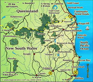
Accessed via Casino and Mallanganee, Tabulam and Bonalbo are in the Upper Clarence Valley, well and truly in the "back blocks" of the Wollumbin Volcano.
Photo © by David Palmer
The primary attraction for settlement in the area was due to the discovery of gold in the mid 1800's.
Dairying and cattle raising, some timber milling, and farmstay, camping and wilderness lodge style of tourism
are now the mainstays.
Budjalung country
Prior to European settlement, Budjalung country was home to an estimated 60,000 people, who shared a similar language and material culture, but composed of 3 tribal groups, each with their own distinct hunting and ceremonial lands.
Gold Rush
A gold rush in 1853 when the precious ore was found in the river, saw an estimated 4,000 men stampede onto the gold fields, and out into the country around the diggings.
By 1863 a punt was established across the Clarence River to ferry people and supplies to and fro, but it was so difficult to access, that many travellers would wait for the river level to drop before crossing.
Accommodation in Bonalbo and nearby
Hint: Mouse over for external site description. External links open in a new window.
Big Volcano Supporters
Accommodation Directory
More Accommodation
Book Direct via Booking.com or choose from the links below
- Amarina Farm Stay and Gardens
- Bonalbo Caravan Park
- The Dog 'N Bull Hotel, Bonalbo
- Wave Hill Station via Baryulgil
- Clarence River Wilderness Lodge via Tabulam
- Emu Creek Bush Getaway via Tabulam
- Lanakai Adventure via Tabulam
- Mallanganee Campground
- The Mallanganee Hotel
- Big Volcano Accommodation Directory
Local Tours & Attractions
Hint: Mouse over for external site description. External links open in a new window.
Big Volcano Supporters
Activities and Attractions Directory
More Tours & Attractions
- Mallanganee National Park
- Richmond Range National Park
- Toonumbar National Park
- Clarence River Canoes
- Upper Clarence Light Horse Memorial
- Big Volcano Activities & Attractions Directory
By 1902 the first bridge to span the Clarence River was built at Tabulam. Notable as the longest single span wooden bridge* in the southern hemisphere, it is 972 feet long by 15 foot wide, or 296 metres long by 4.5 metres wide.
Thanks to Steven Ross of Clarence River Wilderness Lodge ph. (02) 6665 1337 for the "Budjalung Country" historical editorial material.
* This historic bridge was demolished in late October 2020.
Bonalbo
Bonalbo, the heart of the Upper Clarence, was established in 1910.
This quaint village’s name is interpreted from the Aboriginal word ‘bunawblu’ meaning bloodwood tree, which are dotted throughout the region’s lush forests. Bonalbo is also the centre for the surrounding areas for timber, dairying and cattle-grazing industries. Courtesy http://www.visitkyogle.com.au
The community run Bonalbo Caravan Park has six powered sites and 10 unpowered camp sites, and a free-to-use grey water dump point. For further information or to book a site, phone 0417 502 723.
Mallanganee
Settled in the 1880s, by the 1920s Mallanganee was a thriving logging and sawmilling town, supplying mainly Hoop Pine (Auraucaria Cunninghamii) for various markets.
The village name itself is aboriginal, meaning "Place of Tall Pines". The area was once thickly covered with these elegant, pre-historic trees, but now there are very few left.
Kangaroos and Koalas frequently visit the village and Mallanganee is considered to be a core Koala habitat, with mothers and their young a familiar sight at certain times of the year. Courtesy http://www.mallanganee.com/
Mallanganee Campground is behind the Mallanganee Hotel in Sandilands Street. Bookings are not required but please contact the Mallanganee Progress Association on 66645266 to obtain key to facilities. Suitable for caravans and motorhomes. A deposit is required for the key and a donation would be appreciated to assist with the upkeep of facilities.
Tabulam
The Koori Place name of Tabulam means “the originals”. Designated as a town in 1885, Tabulam is historically significant and the only other ‘town’ on the Clarence River other than Grafton. Courtesy http://www.visitkyogle.com.au
As well as being the birthplace of Lieutenant General Sir Harry Chauvel; founder of the two troops of the Upper Clarence Light Horse No 1 (Tabulam) and No 2 (The Border) Australian Light Horse Brigade in October 1885*, Tabulam was also famous for bringing visitors to see the southern hemisphere's longest single span wooden bridge*.
* See Tabulam and the Light Horse Tradition, and Historic bridge demolished.
Activities
Backcountry activities in the area include guided canoe tours, canoe hire, horse riding, fossicking, 4WD tours and private 4WD off road tracks at some bush camping and wilderness retreats.
For the more adventurous traveller, there's also mountain bike trail riding, rock climbing and abseiling, along with the usual bushwalking and bird watching opportunities in the parks and reserves of the region.
The Richmond Valley Council and Kyogle Council jointly publishes a comprehensive touring guide containing maps, scenic drives, calendar of events, history, accommodation, tours, attractions,
and more, which is available from visitor infrormation centres and tourist outlets.
Attractions
Richmond Range National Park. Co-managed with the Githabul People, Richmond Range National Park and World Heritage listed Cambridge Plateau is renowed for the rare Richmond Range spotted gum and extensive old-growth forest supporting a huge variety of native fauna.
At the northern end tent camping ($) is available at Peacock Creek. Two walking tracks, one short and one of about two hours walk, begin at the Cambridge Plateau Picnic Area which has BBQ, picnic tables and toilets. Please note; roads are closed in wet weather.
Mallanganee National Park. Created in January 1999 and covering an area of 1,144 hectares, Mallanganee National Park (formerly Mallanganee Nature Reserve) is located south of Mallanganee village. The primary attraction is Mallanganee Lookout, which offers spectacular views over the Richmond Valley and to Mount Warning in the east. There are no facilities in the park.
Bald Rock National Park. Bald Rock National Park to the west via Tenterfield, is home to what is said to be the world's biggest granite monolith - similar in size and equal in grandeur to Uluru (the world's largest sandstone monolith), and access to the Gondwana World Heritage Listed national parks of the Focal Peak and Gibraltar Range northern tablelands Granite belt.
Getting to Bonalbo and Tabulam
Road
Getting here: Tabulam is about 53 kilometres (klm) west of Casino via Mallanganee, and Bonalbo is about 20 klm north of Tabulam.
Tabulam is approximately 760 kilometres - about 10 hours drive north from Sydney via Casino on the Bruxner Highway, and about 2 hours drive south from Brisbane, via either the Pacific Highway or the inland Mount Lindesay Highway route.
You can also get to Tabulam via the Bruxner Highway to Casino, from Tenterfield (New England Highway) on the Northern Tablelands.
Air
The nearest airport is at Lismore, about 30 klm south of Casino, which has regular commercial services from Sydney, Brisbane and Melbourne, and other regional NSW centres.
Daily flights are available from Brisbane, Sydney and Melbourne to the Ballina/Byron Gateway (about 80klm) and Gold Coast (135 klm) airports, with airport car hire and other car rental services available.
Coach/Rail
Daily coach services from Brisbane, Sydney and Melbourne, and daily or overnight train service operates from Sydney to Brisbane to connect with local transport services at Casino.
