
Uki, Mount Warning Road, NSW, 2484
Head in the Clouds
by Jo-Ann Palmer.
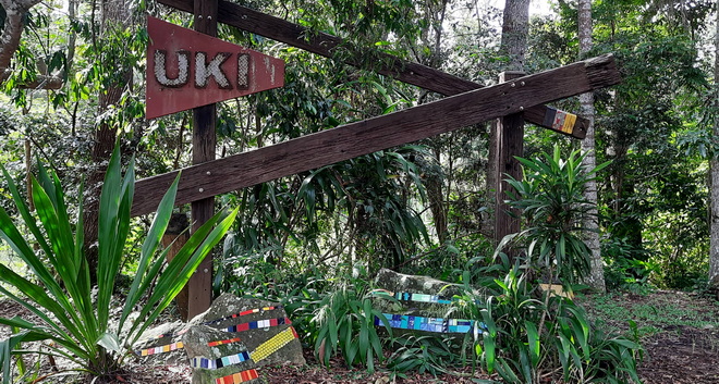
Founded on timber getting and dairying, Uki (pronounced yook-eye) is a beautiful and peaceful village located virtually at the foot of Mt Warning, with the name believed to be derived from the aboriginal name for a water fern with edible roots.
Today Uki is a community based on dairying, with a base of tourist accommodation and residential small acreage.
Situated on the southern arm of the Tweed River, just about anywhere in Uki will provide you with stunning views of Wollumbin/Mt Warning, and ring dykes commonly known as "the 3 Sisters", including Mount Uki.
The World Heritage listed Wollumbin (Mt Warning) National Park is less than 10 minutes drive, and Nightcap and Border Ranges national parks make for a pleasant full day driving tour from Uki.
If you are in Uki you are in the middle of it!
Uki Accommodation
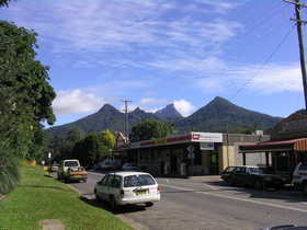 Uki main street © D Palmer, Big Volcano
Accommodation in Uki village and the surrounding area offers a wide range of options.
Affordable camping grounds and cabins at Mount Warning Rainforest Park on Mt Warning Rd, and Hosanna Farmstay at Stokers Siding on the Northern Rivers Rail Trail, are ideal for family and friends holidays.
B&Bs and more luxe couples only retreats include A View of Mount Warning, EcOasis, La Rocher Eco Retreat, and the unique Wollumbin Palms Retreat.
Families and groups can also choose from Chesson Lodge (formerly Uki Guesthouse) which has fully accesible facilities for mobility impaired guests, Mavis's Cabins and Farmhouse, and the distinctive Misty Mountain Manor. And if you're looking for a group retreat venue, Gymea Eco Retreat Centre is available for organised residential retreats.
You can book these lodgings and more via the accommodation links below.
Uki Attractions
The village has been a listed Conservation Area since 1987, with heritage buildings including the old Convent, the old Bank Building, and the NORCO butter factory, now known as "The Buttery", which is home to arts and craft galleries, artisan workspaces, and other retail outlets.
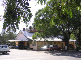 Uki Buttery © D Palmer, Big Volcano
Outdoor picnic tables are dotted around The Buttery to sit down and enjoy a delicious Uki Pie (made with love), while you admire your latest purchase from the Little Gallery - a co-operative of local artists, potters and crafts people, or look over the book gem you discovered at the second hand book shop.
The Uki Community Technology Centre, provides office and secretarial services, internet access and training.
Described as "The last of the 70s style markets", the monthly Uki Buttery Bazaar market on the 3rd Saturday, fills the area surrounding the Buttery "with live music, and stalls with a local focus of handmade, everything bricabrac, plants and good food & coffee."
The Uki Farmer's Market is held each Saturday at the Uki Public Hall, from 8:00 - 12:30, rain, hail or shine, while the Uki Supermarket stocks a wide range of essentials and general products at reasonable prices, along with an impressive selection of local cheeses, meats and other produce for all dietary requirements. Open 7.30am-6pm M-F, and 8am-5pm weekends.
Take a stroll along the main street and pop into fair trade enterprise at The Uki Fair Trade Shoppe, sourcing handcrafted treasures from artisans in Bangladesh, India, Thailand and Peru, or discover your next custom made repurposed furiture piece at Illusive Wood Designs.
Big Volcano Supporters
Accommodation in Uki, Mt Warning and nearby
Hint: Mouse over for external site description. External links open in a new window.
Accommodation Directory
More Accommodation
Disclosure: The links below are affiliate links. If you make a booking and stay after clicking on one of these links, we may receive a small commission at NO extra cost to you. This helps us keep this information free, with no need to subscribe or sign in for access.
- A View of Mount Warning New
- Chesson Lodge New
- EcOasis
- Gymea Eco Retreat
- Hosanna Farmstay
- La Rocher Eco Retreat Updated
- Mavis's Cabins @ Mt Warning Updated
- Misty Mountain Manor New
- Mt Warning Rainforest Park Updated
- Wollumbin Palms Rainforest Retreat Updated
- Big Volcano Accommodation Directory
Local Tours & Attractions
Hint: Mouse over for external site description. External links open in a new window.Activities and Attractions Directory
More Tours & Attractions
- Uki Events
- Bird Watching Walks in the Tweed Valley
- The Big Climb - Mount Warning Summit Walk
- Mount Jerusalem National Park New
- Gidjuum Gulganyi Walk New
- Mount Jerusalem Central Trails New
- Mount Jerusalem Gilwah Trail New
- Mount Jerusalem Unicorn Falls walking track New
- Uki Mountain Bike Park New
- Wollumbin (Mount Warning) National Park
- Battle of the Border Cycling Festival - June
- Clarrie Hall Dam New
- Community Technology Centre @ The Buttery
- Curl Up and Dye Aveda concept Hair and Beauty
- Illusive Wood Designs New
- Ryder's Pioneer Store - The Uki and South Arm Historical Society New
- Uki Fair Trade Shoppe New
- Uki Laundromat New
- Uki Pies
- Big Volcano Activities & Attractions Directory
Eateries
Across the road from The Buttery, the Village & Co Cafe is open on Wednesday to Sunday from 6.30am to 2.30pm (excluding public holidays).
Art Post Uki, housed in the historic 1909 heritage-listed Uki Post Office building, does triple duty as the local post office, an art gallery space dedicated to showing the work of artists from Uki and surrounding areas, and Bastion Lane Espresso, a cafe and Espresso Bar, where they hand-roast the best beans sourced from across the globe.
Just a few doors down, Oscars Takeaway and Cafe, provides more traditional cafe fare with quick and tasty options. Choose from bacon and egg rolls, burgers - with vegetarian options, classic fish and chips, a variety of soups, special blackboard deals, and more, to tempt your tastebuds.
The historic Mt Warning Hotel burned down in 2013 and its replacement has ample off street parking for patrons. Visitors on a scenic weekend drive, looking for a friendly rural pub, can enjoy the country atmosphere, and a break from driving, with the restaurant open 7 days for lunch from 11.30am-2.30pm, dinner from 5.30pm-8.00pm, and pizzas available all day.
Uki Mountain Bike Park
Offically opened in October 2023, the Uki Mountain Bike Park is the Tweed’s first official mountain bike park and pump track.
The park covers more than 6.4 km and includes 8 mountain bike trails, with one climbing trail and 7 descending trails ranging from beginners green and intermediate blue trails, through to a very difficult black diamond trail. There's also a the pump track for all ages, but specifically designed for kids aged 5 – 12 years.
The park is open 7 days a week, dawn to dusk, located at 165 Smiths Creek Rd, Smiths Creek, NSW 2484. See the Tweed shire web page for more information (link to right).
Keen cyclists can also scoot over to Stokers Siding to get on the Northern Rivers Rail Trail for a longer flat and more leisurely ride experience.
Landcare
A number of landcare projects around the village are replacing exotic creekbank species with native trees and shrubs, which includes a project for a Uki Riparian Corridor and Platypus Walk. A rainforest walk along the Tweed River (south arm), is accessible behind the Butter Factory.
And if you go bats over Flying Foxes, a "camp" can be found in trees adjacent to the bridge on the southern side of the village. People seeing them for the first time, often comment on how large they are.
Clarrie Hall Dam
If you want a quiet picnic spot, a few picnic tables are available at Clarrie Hall Dam, south of Uki. Be sure to visit the dam wall and read interesting details about the history of about the dam. (Swimming is not advised.) Access gates close at 5pm.

Mount Jerusalem National Park
More often accessed from Byron Bay via Mullumbimby and Main Arm on the southern side of the caldera rim, access from the Uki side is a shorter 10-15km drive along picturesque rural roads via Rowlands Creek Road (sealed) and Manns Road (unsealed and best suited for AWD and 4WD).
The Central trails wind through eucalypt forest, offering a number of multi-use tracks of around 10 kilometres in length, suitable for bushwalking, mountain biking and horse riding.
The Gilwah trail provides experienced horse riders a chance to enjoy some remote and rugged terrain. Cyclists and bushwalkers can also use this challenging 6km route that traverses a high ridgeline in the park.
Please note, both these trails are shared with motor vehicles.
Unicorn Falls walking track is peaceful bushwalk of just 4.2km return, leading to the picturesque Unicorn Falls. There's a car parking area with no-flush toilets only.
Construction is also underway on the Gidjuum Gulganyi Walk, a new 39-kilometre multi-day walk from the Unicorn Falls car park to Minyon Falls in Nightcap National Park. Once completed, the 3-night, 4-day trek will form part of the NSW National Parks and Wildlife Service network of 13 Great Walks across New South Wales.
It is advisable to check NPWS web pages for latest information on facilities and access to this park. PDF trail maps are also available to download. (Links to right).
Mt Warning Road
Mt Warning Road is on the way to Uki, and just 10 minutes drive from Murwillumbah.
It leads to the World Heritage listed Wollumbin National Park,
And while you can't climb to the summit of Wollumbin - Mount Warning anymore, visitors can still do the Lyrebird walk, a Grade 3 level 300 metre hike for visitors across Breakfast Creek up through palm forest to a viewing platform overlooking the peaceful rainforest. Please note, there is NO camping permitted in the park. Park access gates are open from 7am to 5pm (6pm ADST).
If you want an invigorating dip in pure mountain water, the Korrumbyn Creek Picnic Area, just 1500 metres down from the park entrance, has a handful of off road parking spaces next to small open area with a BBQ, picnic tables, and toilets. A couple of unoffical paths lead to "secret" rock pools, where you can bath at your own risk.
Acommodation on Mt Warning Road includes Mount Warning Rainforest Park (formerly Mount Warning Caravan Park) which offers caravan and camping sites, along with some affordable family cabins. Mavis's Cabins and Farmhouse have couples only cabins and a family group farmhouse, while the adults only Wollumbin Palms Retreat, lets you enjoy the natural environment in luxury.
Please note there are currently roadworks with traffic light controlled single lane access just past the bridge across the Tweed River.
Dreamtime Stories
The Nganduwal people have many Dreamtime stories handed through the generations, with more than one legend attached to "Wullumbini Momoli" / Wollumbin / Mount Warning, and how its name came to be.
Some people say Wollumbin means cloudcatcher or weather-maker, and on any given day, there is usally a smattering of clouds obscuring the summit peak. Others say it means turkey or Warrior Chief. Here are two stories.
Wollumbin – The Turkey
Once, a long time ago, turkeys could fly greater distances than they can today. Well, one turkey flew from Mt Brown. He had joined a gathering of other birds talking, when a giant bird approached. All the birds, the turkey too, were so frightened they flew away quickly.
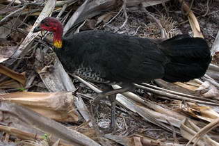
Brush turkey © D Palmer, Big Volcano
The turkey flew all the way to Wollumbin, and stopped on the top of the great mountain to catch his breath. But as he rested, he was wounded in the head by a spear from a warrior.
Because of his head wound, the turkey's flying ability was impaired.
That is the reason why turkeys today can fly only short distances before they must rest; and if you look at Wollumbin you can see the mountain top has a small bend in it where the spear hit the turkey. The mountain tip is the point of the warriors spear.
Wollumbin – The Warrior Chief
The word, Wollumbin, is also said to mean warrior or fighting chief of the mountain.
Legend has it that the spirits of the mountains were warriors. The wounds they received in battles are the scars on the mountainside, and the thunder and lightning are the results of their battles.
If you look today towards Wollumbin from certain angles, you will see the face of the warrior chief in the mountain outline.
Wollumbin is a central sacred site for neighbouring tribes, as well as for the valley tribes. There, special tests were conducted for the men who wanted to become clever men. Not all men were allowed to climb to the suummit, only the clever men.
Excerpts; P43 (names), and P38 (sacred site), from "Minjungbal, Aborigines and Islanders of the Tweed Valley", by Jolunda Nayutah and Gail Finlay, North Coast Institute for Aboriginal Community Education, 1988 ISBN: 0 7316 2824 1.
Getting to Uki and Mount Warning
Road
Getting here. Uki and Mt Warning are approximately 845 kilometres - about 11 hours drive north from Sydney, via Murwillumbah, and approximately 145 kilometres - about 90 minutes drive south from Brisbane, via the Pacific Motorway.
Driving options include the Pacific Highway in New South Wales, and the Pacific Motorway from Queensland, via Murwillumbah, and the Summerland Way in New South Wales, via Kyogle.
Gosel's Bus Service provides a twice daily service between Murwillumbah and Nimbin, with stops in Uki and the Mt Warning Road turnoff.
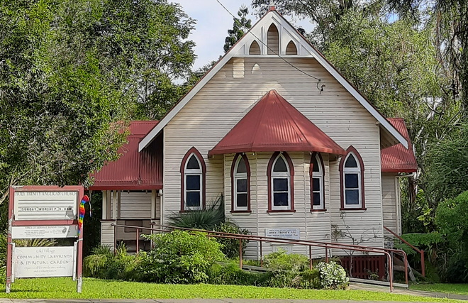 Uki Anglican Church, © J Palmer, Big Volcano
Air
Domestic flights operate from all capital cities to Ballina/Byron Gateway Airport and Gold Coast Airport at Coolangatta. A number of international carriers servicing SE Asia, New Zealand and the Pacific fly into Gold Coast Airport.
Charter flights may also available to Lismore Airport. All airports have airport car hire or other car rental services available nearby.
Daily airport transfer services between Ballina/Byron Gateway Airport and Gold Coast Airport, are available to selected localities in the region, with some shuttles also going to Brisbane International Airport. Visit Gold Coast Airport Transfer Services for more information.
Coach/Rail
Daily interstate coach services are available from Murwillumbah to Brisbane, Sydney and Melbourne, and daily or overnight train service is available from Sydney to Brisbane via Murwillumbah coach transfer to Casino.
Google Ads